Showing posts with label Google Earth. Show all posts

Wednesday, June 16, 2010

Google Earth Gets An Upgrade For The Outdoor Crowd


One of my favorite computer programs is Google Earth, the free software from the wizards at Google that lets you explore the planet from your easy chair. It has always been a fantastic program for travelers and outdoor adventurers alike, and Google keeps updating it, adding new features, and giving us more reason to love the it.

Yesterday, Google Earth 5.2 became available, and brought some excellent new features for hikers, runners, and cyclists alike. The software has been able to connect to your GPS for some time, but now it gives you more enhanced ways to look at the track from your latest hike, run, or ride, showing you a graph, directly in the program, of the profile of your last workout. It also shows your maximum slope, total elevation, average speed, and so on.

Better yet, you can now follow your track, as it's displayed in Google Earth, simply by pushing the time animation button. Those animations can be saved and shared as tours as well, so if you're hiking through Yosemite for instance, you can now send your personal hike to friends and family so they can follow along with the adventure. Pretty cool stuff.

They've also added a new web browser built directly into the software that allows you to view websites and other information without ever leaving Google Earth. That's pretty handy when you're searching for information about a business for instance or some other local point of interest.

Check out the new tracking feature in the video below, then download the latest version by clicking here. Oh! And I almost forgot, Google Earth is now available for the iPad too. You can grab it here.

Monday, December 22, 2008

Google Earth Helps Scientists Discovery Unexplored Forest


Here's a great story in the Telegraph today about how Google Earth was used to discover a hidden forest that had remained unexplored and untouched by man, until the first exploration party visited the region recently.

It seems scientists were using Google's amazing satellite imaging software to examine remote regions of Mozambique when they discovered small region, about 7000 hectares in size, that had yet to be explored thanks to difficult terrain and on-going conflicts in the area.

Naturally, they dispatched a team to explore the area, and discovered a region of rich biodiversity that included several new species of plants and animals. So far, the team has confirmed three new species of butterflies and a deadly new breed of snakes, and are expected to confirm two new species of plants, and possibly insects as well.

An amazing story. It's still surprises me that we have these little pockets of untouched Earth that are still waiting for us to explore them and discover new things there. The fact that you can use Google Earth to find them is just another level of cool. I think I'll go fire up my copy right now and see if I can find my own little piece of unexplored land. Perhaps I can plant a flag there and declare myself Emperor or something.

Tuesday, October 28, 2008

Google Earth Hits The iPhone

I've made it no secret that Google Earth is one of my favorite computer programs. It's crammed with all kinds of information and data about a nearly every place on the planet, and is a great tool for travelers looking for information on their next big destination. On top of that, it shows topography, trail maps, campsites, and much much more, depending on your needs. All for the low, low price of FREE!!

Yesterday, while surfing my favorite websites and catching up on tech news that I'd missed recently, I noticed that Google released a version of Earth for the iPhone, which of course, made me even happier. I downloaded this version, which is also free, and began to play with it.

The first thing I'll say is that this is more like Google Earth Lite. It looks a lot like it's desktop counterpart, and operates in much the same fashion, but it doesn't even come close to having all the same features, nor is there as much data available at your fingertips. That said though, it does allow you to zoom in, pan about, and look at regions all over the world. You can even use the iPhone's accelerometer to tilt your views around. It's pretty cool having Earth with me in my pocket where ever I go, even if it's quite slow on the iPhone's EDGE network. It is, however, relatively speedy on WiFi, allowing you to navigate easily and look up information on a location through Wikipedia.

If you don't already owning an iPhone, the apps like this one keeps making it more enticing. It's incredibly fun to play with, and you can check it out in action in the video below.

Friday, April 4, 2008

Google Maps Add Contour LInes


Google Maps has certainly been a useful item over the years. I've used it numerous times to navigate when in a new city or even to find things in the city I do live in. Having it on my iPhone has been a life saver on a number of occasions. For hikers, backpackers, and climbers however, the feature just became even more useful.

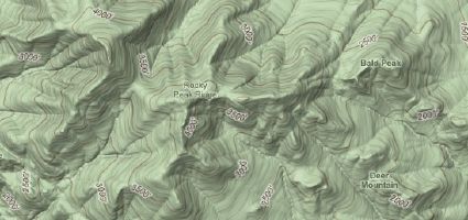
According to The Daily Dirt, one of the new blogs over at the recently redesigned Backpacker.com, Google has seen fit to add contour lines to the terrain view in Google Maps. This means that hikers can now see the changes in elevation much more accurately than before and can get a better idea of what the actual terrain is like in the area they intend to hike. Very useful indeed!

Backpacker listed the links to a few cool locations to show off the new feature, such as Yosemite and Bright Angel Trail in the Grand Canyon. Both great examples of the new feature.

Thursday, November 9, 2006

Google Earth Aids Archeologists

I ran across this article while browsing NationalGeographic.com earlier, and it combines some of my favorite things, namely, NG, archeology, and Google Earth.

I've mentioned it plenty of times before, but for anyone not familiar with Google Earth, it's a free piece of software that you can download to your Mac of PC and allows you to explore the World from your desktop. It uses satellite images and broadband streaming to send you some detailed images of just about any place on the planet. On top of that, the Google Earth Community has added hundreds of plug-ins, locational information, and more to increase the usefulness of the software even further.

Now, according to the article, archeologists are using the program to scout potential dig locations and to observe current digs or other locations of interest from a birds-eye view. The article even states that one archeologist, Sarah Parcak from the University of Alabama-Birmingham, has found more than a hundred previously unknown sites in the Egypts Delta and Nile Valleys. Amazing stuff.

Monday, November 6, 2006

Does Microsoft Have A Google Earth Killer?

I've made no secret about my love for Google Earth Any application that lets me explore the planet without ever leaving my comfy chair is a winner in my book. But now, Microsoft seems to be going after the Google Earth market with it's new Virtual Earth program which seems to have some features that Google hasn't integrated yet. It looks like an interesting product, and I'm looking forward to playing with it. You can check it out in this video for yourself, but you'll have to sit through a brief commerical first.

Not surprisingly, Virtual Earth only runs on Windows and integrates with the Internet Explorer web browser. I use both a Mac and a Windows PC, and love having Google Earth on my MacBook when I head off somewhere. Still, I'll install it on my PC and give it a through going over. Perhaps MS will spur Google to update their version of Earth with some similar features.

Tuesday, October 10, 2006

24 Hours of Moab Coming This Weekend

October 14th and 15th marks the return of the 24 Hours of Moab mountain bike race. Now in it's 11th year, the race has become one of the bigger mountain biking events, with 450 teams, along with their support crews and spectators, descending on the Utah town. As always, I'm sure there will be some interesting stories from the event, and you can follow it over at the Google Earthlings blog. The Earthlings are a team made up of Google Employees who will be riding in the event. If that's not enough for you though, you can also check out the course in the always popular Google Earth.

Friday, September 29, 2006

Top Ten Things To Do With Google Earth

It's no secret that I love Google Earth. It's a great program that also happens to be free, and it's been made all the better with the recent addition of content from the Discovery Channel, the U.S. National Parks Department, and more. Now the gang over at Google Earth Hacks have put together a top ten list of the best things to do with Google Earth, such as find your own home, checkout historical sites, and even track the weather in near real time. The Google Hacks website is dedicated to showing off all the cool things you can do with the program, and they have hundreds of small, downloadable files that can open Google Earth and take you some amazing places or hidden gems in the program. You'll find everything from buildings and bridges, to mountain peaks, to crop circles. It's a great place to get even more out of Google's little materpiece.

Wednesday, September 13, 2006

National Park Service Comes to Google Earth

I've talked about Google Earth before. It's a great piece of software, available for free on PC or Mac that maps out the entire planet and gives you satellite images to explore. Well, a new upgrade rolled out automatically yesterday , has some nice new additions to it, including the ability to see changes to an area over time with a time lapsed slider bar, and a host of new partners providing content and information. One of those partners is the National Park Service, which is now offering information on more than 10,000 trails in 58 different parks around the country. For a hint at what to expect in this new version check out this photo as well as this one.

I already loved Google Earth before this update. It allowed me to quickly find different regions of the world and examine some key features there. But this new verion looks like it could make for a great tool to explore some of the national parks, and plot a trail before ever arriving. I'll have to use this before heading out to Big Bend later this Fall.

Update: You can read more about these updates and how to access them at the Google Earth Blog. I just activated them in my version, along with the new National Geographic and Discovery Channel content.

Saturday, August 19, 2006

AR World Championship Google Earth Course Map!

It may be a little late into the race, but it's new to me, and I thought I'd share. If you've got Google Earth installed on your computer ( and why wouldn't you?) you can check out the course of the race, with current team positions, right in the program. Just go here and download the map. You'll have to be running Google Earth 4 to get it to work though. Very cool!

Wednesday, January 18, 2006

Explore the World From Your Desktop!


Anyone who knows me will tell you that I'm a complete tech geek. I love gadgets, gizmos, and gear of all kinds. I do IT for a living, and I'm always on the look out for some new gadget. As such, I'll be making entries here from time to time about some great new piece of technology that may have slipped under the radar. Today, I have one such item and it's called Google Earth.

Google Earth is a great program that has been floating around on the Internet for awhile, but has only gotten attention in geek circles or amongst geography nerds who want to explore the planet from their desktop. It uses streaming technology to downloaded the latest satellite imagery allowing you to zoom in on nearly any place on Earth and see a detailed picture of what that place looks like. The software will also provide a variety of information on various other locations in the area, including restaurants, parks, hotels, and even places to get a WiFi connection. You can even use it to get driving directions, and Google Earth will show you a map of the route.

On top of that, a large, active community has sprung up around this piece of software. Members of that community are able to place markers on the map to provide more information about an area, or to mark items of interest. You'll find all kinds of wonderful landmarks from around the globe already listed on the maps. Want to see the Eiffel Tower? It's marked. The Great Wall? Yep, it's there too. You can even create mini-tours to various places to show off to your friends. All of this is included in the program, and it's free for download.

As if that wasn't enough, for $20 you can get a version of Google Earth that integrates with your GPS system, allowing you to mark points on the map, and then download the coordinates to your device as you head out for the day, making it even easier to arrive at your destination. There is even a Professional version of Google Earth ($400) that can be used for commercial use and includes even more detailed images and information.

The software has been available for Windows PC's for some time, but has just recently been released for Mac's as well. Download it, install it, and then lose hours while you explore the world. I use it all the time, sometimes just for getting directions, and sometimes just to find cool stuff all over the maps. What cool stuff have you found??